How Oregon State Used ArcGIS and Accessibility Data to Transform Campus Navigation

About Oregon State University:
Oregon State University (OSU), based in Corvallis, Oregon, is a leading public research institution recognized for its land, sea, space, and sun grant designations—one of only three universities in the U.S. with this distinction. With university programs across the state, OSU serves 36 Oregon counties. The university is committed to community engagement, sustainability, and inclusive excellence.
The Challenge: Outdated Infrastructure and Rising Expectations
Before implementing Concept3D, OSU relied on a homegrown campus map built in-house. It proved to be an inflexible solution that demanded significant developer resources for even minor updates. As Michael McDonald, Assistant Director of Digital Experience, explained, “Any kind of change would have required a significant amount of in-house development resources. Strategically, that’s not where we’re applying our efforts anymore.”
Compounding the technical limitations was a pressing mandate for improved digital accessibility. In 2021, OSU launched its ADA 31 Task Force to assess and elevate accessibility across campus. Among the 14 recommendations produced, an accessible, inclusive campus map emerged as a top priority.
“Accessibility was the number one and number two reason we did this project. We had a moral, ethical, and legal impetus to provide better digital navigation for all students and visitors.”
Michael McDonald, Assistant Director of Digital Experience

A Campus-Wide Commitment to Accessibility
Following the ADA 31 Task Force recommendations, OSU prioritized the creation of a new IT digital accessibility policy before diving into map development. Ramee Kelly, Strategic Efforts Coordinator for the Office of the CIO, emphasized the university’s commitment: “One of OSU’s values is advancing inclusive excellence. We were doing accessibility but we weren’t living up to our own values. This initiative was a necessary reflection of that.”
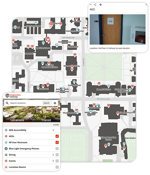
The cross-campus collaboration involved stakeholders from IT, facilities, public safety, disability services, and university marketing and communications. This diverse working group enabled OSU to incorporate accessibility features like:
- Steep paths and stairs
- Accessible parking locations
- Lactation rooms
- All-gender restrooms
- Wheelchair-accessible routes
The data for these features was already being tracked in ArcGIS thanks to years of preparation by Gabe Merrill, Director of Access for the Office of Equal Opportunity and Access.
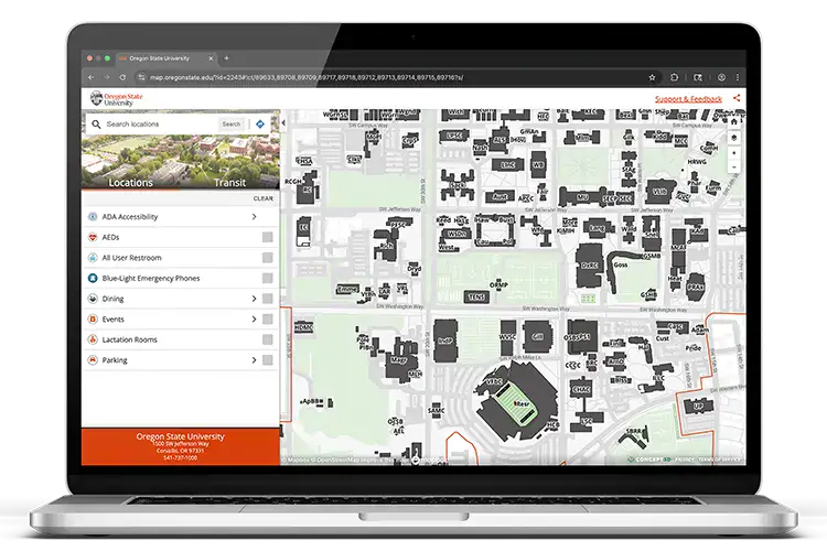
ArcGIS Integration: A Single Source of Truth
One of the most impactful elements of the new map was its seamless integration with OSU’s ArcGIS database. As McDonald explained, “ArcGIS is the bucket where we keep information about our places.” This includes everything from building outlines to locations of defibrillators, restrooms, and accessibility infrastructure.
With campus-wide initiatives like OSU’s Administrative Modernization Program putting a strain on IT resources, simplifying system integrations was critical. “We didn’t want to have Concept3D integrate with five different systems,” said McDonald. “We wanted one meaningful integration with one tool and a single source of truth.”
This approach streamlined data management and improved accuracy and clarity of ownership. “Validate the quality of your data and identify clear owners,” McDonald advised. “Ask hard questions like who’s updating this and when was it last updated?”
Custom Tiles for a Personalized OSU Experience
OSU customized Concept3D’s default renderings and opted for custom map tiles that reflect its unique identity and branding. Collaborating with their Facilities team, OSU created stylized tiles featuring correct court markings, branded stadium fields, and familiar visual cues.
“We wanted something visually engaging, aligned with OSU branding, and that gave us more control,” said McDonald. “It’s not just about aesthetics. Those visuals help people orient themselves and understand the space.”
Measurable Impact and Real-World Use
The map launched just in time for OSU’s AI Week, which hosted more than 50 individual events and over 2,000 attendees.
Early feedback has been overwhelmingly positive. One faculty member expressed how the new map made it significantly easier to plan campus visits with a family member who had mobility needs. “It’s already making a difference,” said Kelly. “People are genuinely grateful to have this information at their fingertips.”
“The map is one of the first digital experiences prospective students and families have with OSU. If it’s not accessible and inclusive, what message are we sending?”
Michael McDonald, Assistant Director of Digital Experience
Flexibility, Responsiveness, and Partnership
With direct access to the Concept3D content management system and live ArcGIS data feeds, OSU can now make fast, reliable updates without needing heavy developer involvement. “We can make quick changes and iterate fast,” said McDonald. “That’s a huge win.”
The launch of Concept3D’s Interactive Map helped OSU meet its goals of offering trusted data, simplified integrations, and a personalized digital experience.
“Our real philosophy around accessible wayfinding is to give people the information they need to make decisions, not assume we can make the decisions for them.” stated McDonald.
OSU also highlighted the exceptional experience of working with the Concept3D team. “It’s been genuinely a pleasure,” said McDonald. “We’ve worked with Concept3D for years through our Localist Events calendar. Their support continues to align with OSU’s mission and values.”
A Path Forward
For OSU, the launch of Concept3D’s Interactive Map represents more than a technical upgrade. It’s a tangible reflection of the university’s core commitments to accessibility, data stewardship, and inclusive student experience.
“The OSU project team focused on creating a modern, fully navigable campus map to enhance wayfinding for the Corvallis campus,” said Ramee. “This initiative highlights OSU IT’s commitment to trusted data, simplified integrations, and personalized digital experiences.”


Transform your online experience.
See our technology solutions come together in one seamless experience.