Mapping is a complex topic. For both individual and business uses, the opportunities over the last few years have expanded drastically to solve a variety of different, often complex needs.
To most consumers, the core purpose of digital maps remains simple: you just need directions to the nearest dry cleaner or that great restaurant you heard about. Solutions like Google Maps, Waze, and Apple Maps have carved out a niche to solve this need.
However, these opportunities are far from the end of the line when it comes to modern mapping solutions. On the contrary, they’re just the beginning.
With the right development and integrations, digital maps are able to optimize fleet tracking, warehouse management, and space planning. They can visualize future changes in a physical area long before they actually occur. They can even tie together with existing ERP software to revolutionize and change the way you think about business analytics and digitization.
Getting there, of course, is a complex process. The same virtual mapping software will not function equally well for all potential needs. You need to know exactly what software, and underlying technology, will work well for your scenario and business. We’ll explore some of the more common options in this article.
3 Core Components that Define The Type of Map Your Business Needs
Before going into depth on specific technologies and virtual mapping software, we need to define the components according to which you will actually look for the right solution. This section is, in essence, the more in-depth version of a business pain point; it helps you define exactly what direction you should look in before beginning your search.
All three of the below questions are software-agnostic. They remain true, regardless of whether or not you prefer a specific technology or vendor. In fact, they should prelude that step precisely so that you find the right technology and vendor for your needs and requirements.
1. What Are Your Business Mapping Needs?
At its most basic, this is your core reason to use the map. But it goes deeper than that. Try to examine what, exactly your business actually needs if it incorporates a mapping solution.
Some questions you might want to ask include:
- Does the map need to connect with any of your current software, such as an ERP or any other custom platform that your business runs on?
- Do you plan on connecting the map to common data sets, including transit feeds like GTFS or a geographic information system like ArcGIS?
- What part(s) of your business do you plan to intersect your mapping solution with? What unique requirements might that business side have that you should keep in mind at all times?
The more specific you get in this section, the better. That allows you to ensure that the solution you end up with truly solves your business need.
2. How Do You Plan to Use the Virtual Mapping Software?
From business needs, we move to use cases. Naturally, these first two components should be closely connected to each other. Your business needs should determine the use cases and vise versa.

Ask yourself a few core questions to narrow down exactly how new maps might be focused in terms of use:
- Will you need the map for operational use or marketing opportunities? In other words, are the audiences internal or external?
- Will the space you’re looking to map be internal or external space? That will make a major difference in the types of software and platforms that make sense for you.
- Would your business benefit from 3D mapping, or are simple 2D/flat representations just as beneficial for your core use cases?
- Will wayfinding and indoor positioning become an important component of the map?
- Will you need comprehensive mapping analytics, or is the core purpose of the map in the moment, instant satisfaction?
Think carefully through your use cases. If you pick a mapping software and then discover new potential uses, it might not be able to stand up to your needs and pain points.
3. What Resources Do You Have Available?
Finally, don’t underestimate the resource component of finding a virtual map solution. Businesses of almost any size, from startups to large enterprises, can benefit from the right map. But based on their resources, their solutions likely look very different.
Ask yourself:
- Will you have development resources available to both create the map and maintain it over time?
- Is it possible you’ll benefit from the aid and guidance of an external partner with experience and expertise in the mapping space?
- Will your mapping edits and updates be completed entirely by developers and technological experts, or will you have a need for non-developers to make edits as well?
- What is your budget for the map, both in terms of the initial implementation and in the way of long-term updates and maintenance?
Your available resources are very much a limiting factor. They will determine which solution is right for you, not just because of the right business need or use cases but also in terms of realistic expectations and affordability.
Defining Technology and Available Virtual Mapping Software for Potential Use Cases
The first step above has set the stage. You’re prepared to look specifically for the types of maps that you need according to the uses you will need them for and your available resources. Now, it’s time to take a closer look at exactly what technology is available for your parameters.
Available Virtual Mapping Software for Individual and Narrow Use Cases
Some use cases of maps remain relatively simple. You might need more than directions to your local supermarket, but don’t need to dive into the depths of remote sensing and GIS.
In that case, services like Mapquest and MapMe might be the right choice. They enable you to take existing maps and customize them to more specific use cases. For instance, you can place markings for your property, plan a route, or take other action on top of an existing map layer, then share that layer with others.
The free version of the Open Street Map (OSM) project is similar but more advanced. It offers more functionality, thanks to the extensive network of users that have customized layers already. Think of it as a crowdsourced way to build customizations for maps.
This type of map tends to work well for planning on existing surfaces that don’t need specific custom mapping. They lose effectiveness when you have to get more specific, which is when other technologies begin to come in.
HD Maps for Centimeter Precision
You have probably heard about the rise of autonomous, self-driving vehicles that are poised to change the way we think about traffic. But you might not know one reason why tests have been so successful: HD mapping.

Here’s how Geospatialworld.net defines the technology:
The maps that are particularly built for self-driving purposes are usually called High Definition Maps or HD Maps for short. These maps specifically have extremely high precision at centimeter-level. This is because the robots need very precise instructions on how to maneuver themselves around the 3D space.
This is a true 1:1 mapping solution. Every bit of precision is translated straight onto the map. That requires a number of sensors that add in real-time information almost constantly. The environment created in the map is never static but always adjusts according to what these sensors pick up and translate.
The cars themselves, in other words, create the map by adding in that real-time component. It’s a technology still in its infancy, but with fascinating business possibilities for fleet control, planning, and more.
LIDAR Creates Exact Survey Maps
Consumers might think of free maps like Google Maps as precise. In reality, they measure only a fraction of the available space – just enough to help with directions. To get more exact survey data of exterior spaces, businesses tend to use technology like LIDAR.
The National Ocean Service defines LIDAR as
a remote sensing method that uses light in the form of a pulsed laser to measure ranges (variable distances) to the Earth. These light pulses—combined with other data recorded by the airborne system— generate precise, three-dimensional information about the shape of the Earth and its surface characteristics.
This system, in other words, creates precise surface mapping that can be used in a variety of business applications. It’s particularly common in hazard assessment (including lava flows, landslides, tsunamis, and floods), forestry, agriculture, geologic mapping, and watershed and river surveys. Other uses include city planning as well as mining, both applications in which the precision of the map (and its three-dimensional nature) are core components of its use.
OSM Builds Maps for Advanced Business Needs
We already mentioned OSM briefly above, and it’s worth digging into more of the possibilities this open-source software truly brings. We’ve written extensively about the state of OpenStreetMap, especially after our attendance at a get-together of the OSM community last fall. Some of our core takeaways from the State of the Map conference are particularly relevant as you consider business use cases for your own map:
- OSM can leverage artificial intelligence for more accurate and comprehensive data, which is especially important for businesses looking for extensive integrations on their mapping solution.
- It has made strides in mapping and visualizing crisis areas, where (through satellite imagery) it can contribute significantly to disaster preparedness and response.
- The focus of OSM is beginning to move beyond buildings. The conference saw presentations of organizations using its interface to include alternative guideposts, like trees and benches, to build better maps for the handicapped and elderly population.
Unlocking these features and potential uses of OSM takes extensive skill and expertise. Only businesses with direct access to a development team can fully leverage its opportunities. Once unlocked, through OSM or OSM tiles in Mapbox, the sky is truly the limit with this software.
Aruba Can Integrate Well With ERP Systems
Aruba is a Hewlett Packard enterprise that has made a name for itself in recent years for providing user-friendly indoor mapping solutions with extensive data integration.
The software can easily be customized, using JavaScript opportunities, and tends to integrate within an ERP system for more holistic management experience. More importantly, the use cases are expansive because this software doesn’t just allow for mapping; it adds location tracking and real-time data through mobile beacons.
The use of beacons in virtual mapping software is complex and probably requires its own article to explain both current opportunities and future possibilities. For now, the biggest takeaway should be that they allow for more location-based communication and navigation, leveraging methods like push notifications to closeby mobile phones.
These features make Aruba a great solution for customer-facing maps, particularly for large spaces indoors. The use cases on the website tend to revolve around these types of spaces, from shopping malls to airports. It’s another example of how the use case should define the type of technology on which you build your map.
Working With a Partner to Build the Right Right Virtual Mapping Software
All of the above are important considerations and show just how much virtual mapping software diverges based on the different business needs an organization may exhibit at any one time. They can also easily get complex and confusing, particularly for companies who might not have an internal developer team or expertise to find and develop a custom, bespoke solution that fits these business needs.
Sometimes, LIDAR is the best solution. In other cases, OSM is better. Software like Aruba may be perfect for consumers but does not offer the precision of HD mapping. Just what direction should you take your map in?
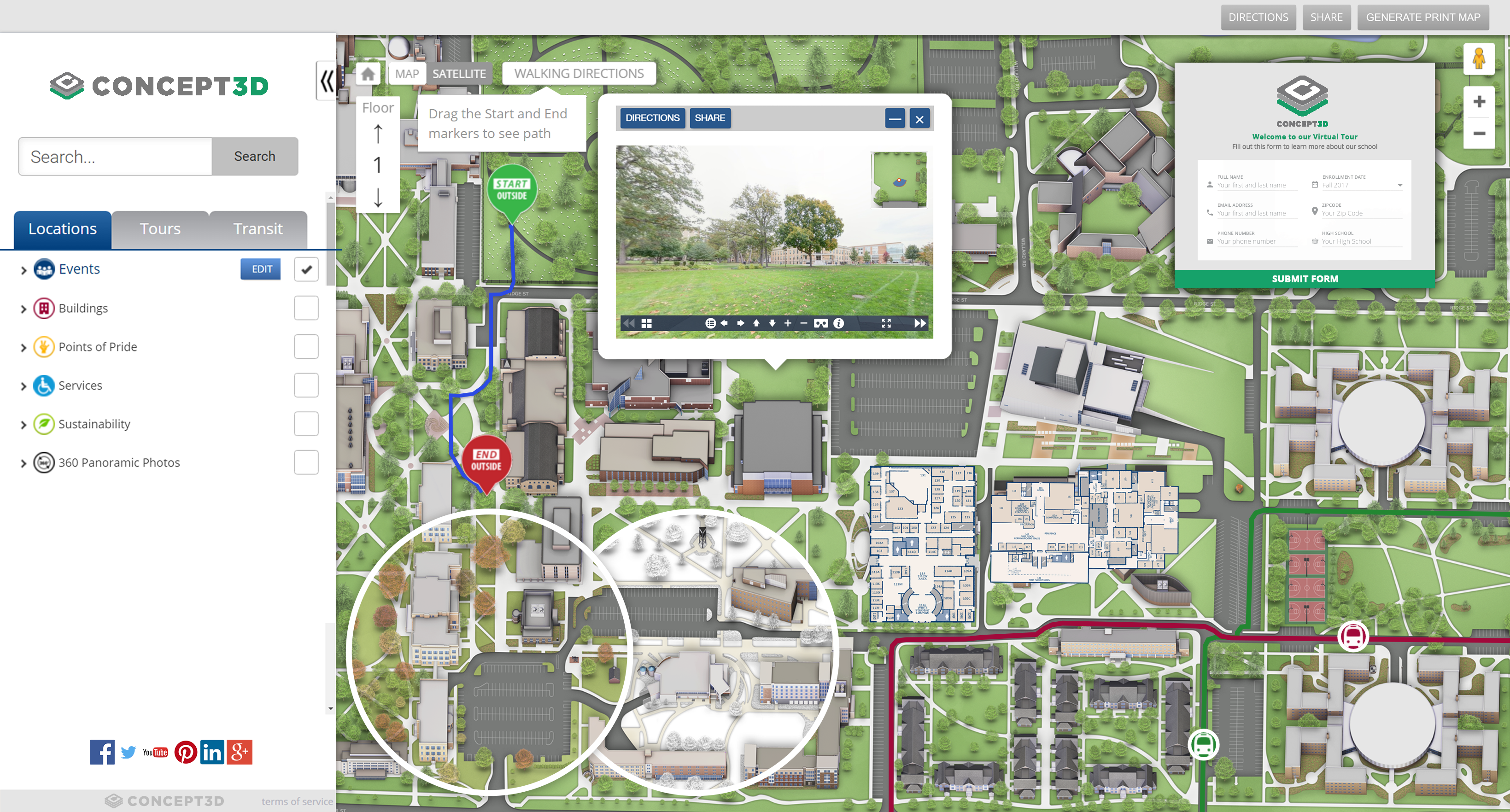
That’s where a partner like Concept3D comes in. Our experience in the mapping space, particularly in 3D mapping focused on wayfinding and indoor/outdoor positioning is especially relevant for companies who might not have a development team internally and need external help. We operate in the enterprise map space that designs maps for business use cases, even though the ultimate audience may be consumers.
Interested in learning more about virtual mapping software? Contact us today. Let’s talk about a virtual mapping platform and content management system that matches your needs, use cases, and resources.