
With the help of next-generation 3D mapping solutions, universities can now immerse students, staff, and prospective visitors in the wealth of sights, sounds, and unique highlights that their campuses offer. This feat is accomplished through a set of highly advanced features – breathtaking 3D artistic renderings, rich informational overlays, live data feeds, best-of-breed virtual tours, floor-by-floor indoor maps, highly interactive campus virtual tours, and flexible, vivid campus wayfinding paths. All of these features are made possible by a state-of-the-art content management system (CMS) designed for endless customization.
Here we explore each of these interactive campus mapping essentials and how universities such as Rice University, the University of Denver, and Arizona State University are using 3D mapping solutions to help and amaze students, parents, faculty and visitors.
If you work in marketing and communications for higher education, read why an Interactive Campus Map is a Perfect Tool for University Communications.
3D Artistic Renderings
The campus mapping solution you choose to represent your university to visitors, students, parents, and faculty speaks volumes about the technological and artistic prowess of your university. A best-in-breed interactive campus mapping solution will include 3D artistic re-creations of your campus that will amaze even the most casual viewer. One of the most useful aspects of artistic renderings is that they allow you to highlight key features of your campus buildings and facilities without cluttering them with extraneous detail.
For example, an artistic rendering of your campus buildings’ rooftops could call-out the new solar panels you’ve added, reminding visitors that the university has backed up their commitment to environmental sustainability with an investment in alternative energy sources. Moreover, a state-of-art 3D artistic rendering of your campus stadium could do justice to the unique character of your prized venue in ways that no satellite image or aerial photograph possibly could.
Overlaying Rich Datasets
In order for your campus mapping solution to do justice to all the features your university has to offer, it needs to provide a highly intuitive navigational toolset with a rich array of location categories, such as Transportation and Housing. Users should be able to easily turn these location categories on and off with a single click to highlight their interests and hide any distractions on the campus map. When a location overlay is turned on, the corresponding highlights will often appear as icons that provide images, links, videos, and other media when clicked.

For example, suppose a prospective student is viewing Rice University’s interactive campus map and has a strong interest in the performing arts. With the help of the map’s interactive list of location categories, the student can instantly turn on the Art & Performance location overlay and watch the map light up with arts and performance-related locations on campus. A complete solution, such as Rice University’s, will also allow the user to drill-down on these location categories to achieve greater specificity, such as Art Venues or Public Art.
Live Data Feeds

An advanced mapping solution can enrich a campus map still further with live data feeds. Ole Miss, for example, enlivens their interactive campus map with real-time parking availability information. Users simply click on the LiveCams category, then on any location. The campus map will instantly highlight all campus live web cams. By clicking on a particular location the user can view what is happening in real-time all over campus
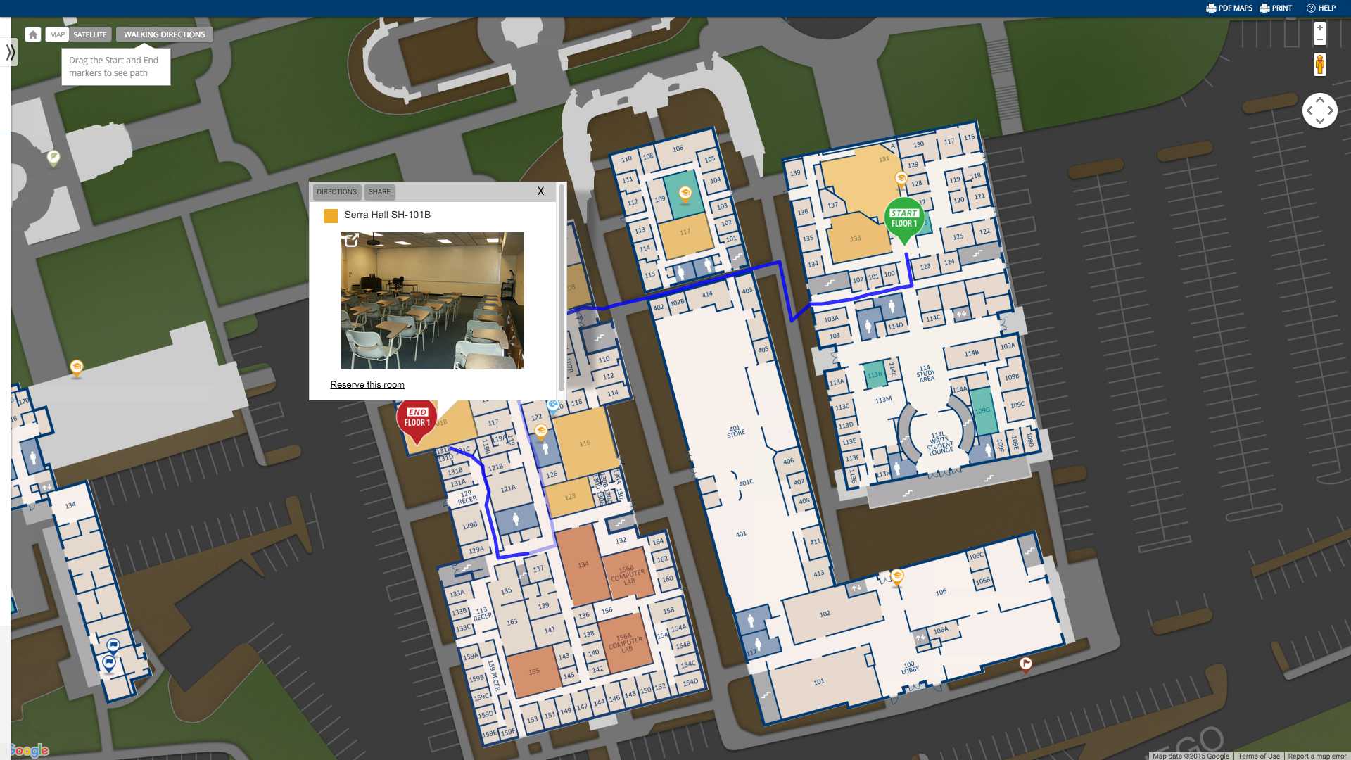
Indoor Mapping
A highly advanced campus mapping solution can also provide users with the option to toggle between the exteriors and interiors of campus buildings. When viewing floor-by-floor interiors, users can easily zoom in on the precise location of a room or other indoor setting they wish to visit. ASU, for example, provides a stunning, interactive example of indoor floor mapping, allowing users to click on a specific room on a specific floor to view a real-world image of it, then reserve the room if they have the proper permissions.
Campus Virtual Tours
The best interactive mapping solutions should always provide a seamlessly integrated virtual tour featurethat immerses users in a stunning virtual visit of your campus. Especially useful for attracting prospective students, a state-of-the-art campus virtual tour can complement a path through your campus with high-resolution video footage, virtual reality (VR), elegant media embeds, crystal-clear audio, and 360° photospheres.
For example, each stop along the University of Denver’s integrated virtual tour (found through their Tours tab) offers users a wealth of additional information and media, such as on-the-ground photography and student videos related to the point of interest at hand.
Campus Wayfinding
State-of-the-art campus wayfinding is also a must-have for a complete campus mapping solution. The most advanced wayfinding technology will even allow you to let your users generate wayfinding paths throughout your campus automatically.
At ASU, for example, users can simply drag-and-drop a large green Start icon to mark the beginning of their wayfinding path and a large red End icon to mark the end of it. Because ASU already has campus building interiors mapped, their Start and End icons not only give their users a wayfinding path from building to building, but from room to room. Once the Start and End icons are in place, the wayfinding path instantly appears on the campus map for users to follow. The map ties into the location-services feature of their users’ smartphones to make the navigation process even easier.

Customizing Campus Maps
An advanced 3D mapping solution will not only deliver a breathtaking 3D map of your university’s campus, but a powerful content management system (CMS) that plugs into all key departments in your university. Therefore, when comparing campus mapping solutions, be sure to pay close attention to the feature set of the CMS, as this will determine the degree of freedom you will have to customize your interactive maps. If the CMS has sufficient flexibility, then university departments such as Admissions and Marketing can specifically tailor their 3D map to students, faculty, parents, investors, alumni and other important audiences.
For this reason, always look for a campus-focused 3D mapping solution with a rich CMS that offers a robust set of tools for customizing your campus maps to virtually any visitor’s needs or interests. All of the examples above (showcasing what universities can do with their interactive campus maps) are facilitated by a robust CMS that gives universities the creative power for endless customization.
If your university is looking to utilize 3D mapping solutions to help amaze students, faculty, and parents, then look no further than concept3D. Our expertise in interactive 3D mapping will ensure that your university gets an interactive map that displays your campus in its truest beauty. Please contact us today!