
When it comes to communications, higher education is unlike almost any other industry. There is no single target audience or product line; prospective students, current students, alumni, employees, and the local community all have vastly different needs and preferences in terms of the visuals they see and the information they need. As such, it would be foolish to call any platform the perfect communications tool for colleges and universities. Interactive campus maps, though, come close.
Make no mistake: the interactive maps we’re about to discuss in this article are far more than your traditional campus map, a fold-out used solely for wayfinding purposes. Instead, they take hard-to-communicate data and transform them into something much more easily digestible.
That’s not just a generalized statement. Just consider some of the factors that make interactive maps such a valuable platform for higher education marketing and communications. These are our 8 favorite features of digital campus maps at their best.
1. Communicate Your Building Status and Plans
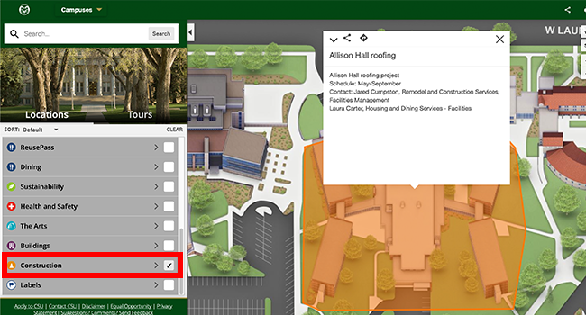
The modern college campus is never constant. Construction, from necessary to aspirational, will always be a part of the environment. Whether it’s a new student building or replacement of old water lines, finding your way around campus can be challenging without an overview of what’s happening, and where.
Fortunately, interactive maps can communicate exactly that. You can draw areas of construction, and automatically adjust directions to move around them. You can even create proposed routes to get from one area of campus to the other without running into construction.
As an added bonus, highlighting construction areas also allows you to communicate your vision for your university’s future. That building site for the new student center could be an opportunity to highlight. How you plan to become a student-first institution with their well-being at the heart of it, for instance.
2. Create Helpful Live Data Feeds
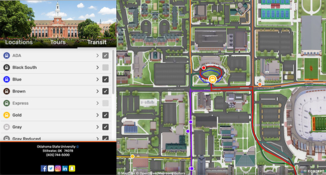
Modern campus maps are no static tools. They’re opportunities to show off your campus and help your community in real-time, thanks to data integrations that can be leveraged in a wide range of ways. Take just two examples of how to integrate data into your map:
- Oklahoma State University highlights live bus schedules for all of its shuttle buses, minimizing the chances of missing a shuttle and providing help in getting across its massive campus.
Of course, these are only two of the many examples of how live data can make an impact on your map. Anything from social media integrations to live cameras can build a more interactive, engaging, and helpful experience.
3. Help With Daily Wayfinding Needs
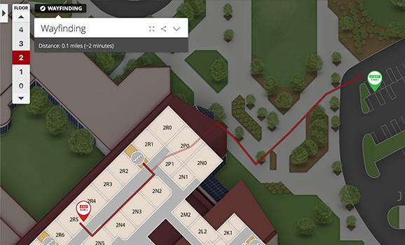
Sometimes, it’s just about simple wayfinding. Students on their first day, parents when they visit, external visitors, and alumni when they return will all need to know where to find the right buildings and how to get there. Campus maps can help.
Every building and highlighted campus spot is uniquely searchable and linkable. The right mapping tool also integrates GPS navigation to get to that specific building. That way, both broad and individual communications are made much more simple and straightforward. A professor looking to guide a guest speaker to their classroom for a specific day
4. Support Major University Events
Every university has a few events during the year that just get the entire campus moving. Think Homecoming, Commencement, or Move-In Day. What if your map could become an active part of the communications for that special day?
Check out our recent article on building map layers for Move-In Day as an example. Custom tour stops, and descriptions can all help to guide audiences through the event, easing the procedural part of the day and allowing your visitors and stakeholders to focus solely on what matters most: an enjoyable, fruitful campus experience.
5. Highlight Campus-Sponsored Housing for Guests
For both major university events and everyday visits, your campus guests will have a need for lodging. Some times of the year, like Move-In and Homecoming, make that stop more vital than others. But between conferences, guest speakers, and simple casual visits, the basic needs will always be there.
What if you could use your interactive map specifically to highlight lodging options? Texas A&M University, for instance, focuses on its on-campus hotel through a brochure-like presentation that outlines exactly why guests should stay here instead of other hotels in town.
Because it’s a campus location, the hotel can be integrated within the map, automatically building visibility in the process. That also means it can be integrated into some of the event-specific map layers and experience outlined above. The result: a more comprehensive, beneficial planning tool for any guest looking to come to campus.
6. Show off Attractions Around Campus
It’s tempting to think of campus maps as just that — stopping at the campus border, while focusing on all the areas, buildings, and spaces on campus that your audiences can take advantage of. But in reality, the potential uses and benefits of your interactive map can reach far beyond that step.
For instance, consider using your map to highlight important off-campus locations that your audiences might be interested in:
- Local shopping opportunities
- Restaurants within walking distance of campus
- Local attractions, like museums or an escape room.
- Outdoor recreational opportunities like trails.
Once again, highlighting these opportunities allows you to not just increase their visibility through a separate map layer, but also integrate them into your various event-specific layers and tours. Pro-tip: work with your local tourism bureau to determine what opportunities to highlight, and get the assets you need to profile them in an attractive, engaging way.
7. Promote Your Global Reach
Study abroad has become an increasingly important part of many U.S. college students’ educational experiences. According to the Department of State, approximately one in 10 students study abroad at least one semester during their undergraduate years, and that does not include shorter educational trips or internships.
Your campus maps present a crucial opportunity to showcase these opportunities. For example, you can show a world map, with pins and locations for every country in which a student is currently studying. Work with your international education office to get visual and content assets to further describe the experiences and increase their appeal to potential students and families.
Of course, showcasing your global reach can go beyond study abroad, as well. You can use the same map features to highlight international partner schools and campuses, or even countries in which your alumni are now making an impact. Once again, the map becomes far more than a wayfinding tool, turning into an opportunity to highlight the impact your institution and students have made and are continuing to make on the world.
8. Create Self-Guided Campus Tours
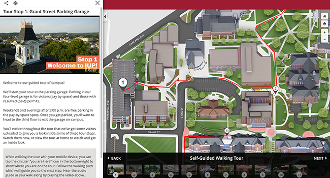
The COVID-19 pandemic has created a sense of uncertainty in recruiting students that is unmatched in recent years. For many universities, guided campus tours and open houses were completely off the table during the 2020-21 recruitment cycle. While undoubtedly challenging, this shift has also created significant opportunities for finding alternatives that work just as well, if not better.
The Indiana University of Pennsylvania, for example, has created a self-guided campus tour for prospective students and their families. The tour features 11 stops, starting at the parking garage and walking visitors through the same areas a guided tour would take. Audio snippets, recorded by student tour guides, help to guide the visitor and provide helpful info.
It’s easy to see how this concept can translate to a time when guided tours are once again possible. It puts visitors at the controls, allowing them to plan a visit at their convenience rather than pre-scheduled times. Because the self-guided tour is integrated into the GPS map, each stop is easy to find and wayfinding directions can keep all users on the right path.
Ready to Turn Your Campus Maps Into a Powerful Communication Tool?
Put it all together, and one thing becomes clear: campus maps have become far more than the static fold-outs of the past. They have turned into communications tools that allow universities to tell the right audiences the right things at just the right time.
Done right, these maps and their features can even be integrated into your more traditional communications, as well. A live data feed of bus schedules might make sense to link at each bus stop, as does emailing your Homecoming map layer to alumni who register for class reunions. That’s how the simple map becomes a multi-channel tool that maximizes your opportunities and minimizes confusion.
Of course, you need the right platform as well as the right partner to get to that point. That’s where we come in.
Concept3D has made its name in helping universities build dynamic, interactive campus maps. In fact, all the examples mentioned throughout this article have been built in our platform, with the help of our experienced production team. Ready to learn more about our platform, and turn your own map into the communications tool you need? Contact us to start the conversation today.