The verdict is in: interactive campus maps are no longer optional for colleges and universities looking to highlight their physical environment. Given the benefits and beneficiaries of these digital maps, which range from admissions to facilities, they’re an essential addition to your online presence and virtual experience.
But, of course, not all campus mapping solutions are created equal. The fact that a simple Google search for ‘digital campus map’ unearths more than 200 million results shows just how many alternatives are available to build that digital experience you’re looking for.
Which brings up the natural follow-up question: how do you know which of these seemingly countless campus mapping solutions is right for your institution’s needs and audience?
The answer, as you might expect, is complex. So let’s simplify it just a bit. Consider these nine elements as crucial things to think about when looking for campus mapping solutions that are designed to help your promotional, communications, and wayfinding needs, both short-term and long-term.
1. A True Bird’s Eye View
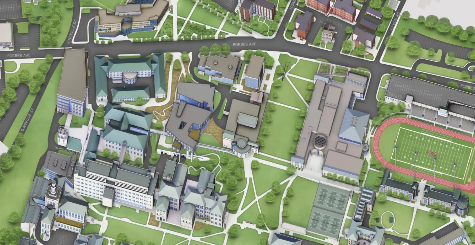
Campus mapping solutions are, and should be, primarily about functionality. Yes, they can look great. But that great look should never impede your audience’s ability to easily see the details of your campus walkways and buildings. That means a bird’s eye view is absolutely essential for your map.
In fact, a bird’s eye view like the one provided by Google Maps is the only way to truly see every part of your campus from the right perspective. You might come across solutions that look like the perspective is from the top of the hill, which introduces intriguing 3D elements to the equation. But while that may look nice, it’s clear that nice looks are the only priority.
In a non-bird’s eye view, you’ll miss out on potentially important details. For example, consider how a building may hide the road or path behind it. Only a bird’s eye view allows you to truly showcase and display all parts of campus, down to the smallest details.
2. Actionable Wayfinding Integrations
Perhaps the biggest advantage of digital campus mapping solutions compared to their printed counterparts is their interactivity. Couple that with their primary use of wayfinding, and one thing becomes clear: the solution you choose absolutely has to include modern GPS and wayfinding integrations.
There are a few ways to accomplish that goal. Perhaps the most common is a solution similar to what Concept3D does: an integration with an established wayfinding tool like Google Maps. That way, you get all the benefits of that option, like walking directions, integrated directly into your custom campus map.
Functionalities, of course, have to expand as you go deeper into your map. For example, if your campus map includes interior floor plans, wayfinding should also involve finding specific rooms within buildings. Look for a combination of nuance and ease of use to ensure maximum usability for your audiences.
3. Easy Editability of Features and Categories
Printed campus maps are defined by their versions. But virtual campus mapping solutions, if you choose the right option, don’t have to be. If you look for a platform that you can easily edit, you’ll be able to leverage a few benefits while using the map for your campus:
- Quickly add temporary changes to campus, like a new use for a building, a new walkway, or a construction zone.
- Show off unique parts of your campus during specific times, like focusing more heavily on areas of interest for alums during homecoming season.
- Add new campus features beneficial to your audience, like new accessible bathrooms for visitors and students with disabilities.
These types of changes don’t happen on a deadline or a predetermined schedule. Think about how much your physical campus layout and wayfinding probably changed during COVID-19. This consideration ensures that as your campus changes, sometimes unpredictably, your digital map can change with it.
4. Custom Category Options
Speaking of highlighting your campus features: have you considered how campus mapping solutions can help you showcase your unique features to core audiences?
Built the right way (and on the right platform), your digital map becomes much more than a wayfinding tool. For example, you can highlight all the sustainability efforts across the university. In addition, you can showcase popular biology research sites, accessibility features, or even popular things to do in town and beyond campus borders.
Showcasing these unique features is possible when you find a mapping solution that allows for custom category options. So, in addition to your standard buildings and parking lots, you can now use the map as a canvas to highlight exactly the types of physical features that support your brand and core messaging.
5. An Accessible User Interface
Showcasing your campus accessibility, of course, is only part of the equation. Any campus mapping solutions you’re considering also have to be accessible to all of your users.
Research has shown that while 26% of Americans live with a disability, only 3% of the internet is truly accessible for all users — including those with disabilities. Your virtual campus map should be part of that 3% to ensure that all of your audiences can equally enjoy its benefits.
We’ve previously written about what it takes to make your digital map accessible for all users. The right solution is intuitively accessible. It needs features like easy keyboard navigation and screen reader compatibility.
6. Compatibility Across Devices
Speaking of compatibility: do you know which devices and browsers your audience typically uses to learn about your university? It’s almost certainly more than one:
- Google Chrome
- Firefox
- Microsoft Edge
- iPhone
- iPad
- Samsung Galaxy
- Google Pixel
- Chromebook
- Leap Pad
- Macbook
- Desktop
Between browsers and devices, the possibilities are nearly endless. The right campus mapping solution is equally usable on all of them, adjusting seamlessly to different screen sizes and potentially even offering direct integrations with your university’s native mobile app.
7. Form and Website Integrations
Don’t think of your campus map as an isolated wayfinding or communications solution. Instead, think of it as part of a larger digital ecosystem, all designed to get your core messaging across to your audience.
Accomplishing that goal, of course, is only possible if the campus mapping solution you choose integrates tightly with your larger digital experience. We’ve already mentioned mobile app integration above; as it turns out, the integration possibilities go far beyond this one option.
Consider, for example, the ability to integrate web forms directly into your campus map. Through a menu item or pop-up, visitors will be able to provide their contact information in exchange for something they want. That might be registering for a campus visit, providing feedback on the map itself, or simply learning more about your university.
Integrations with your website are just as vital in building that larger ecosystem. Building descriptions, for instance, can link directly to web pages; for example, you can link your admissions welcome center to your admissions landing page. Also, if your map vendor offers a virtual tour, you can integrate both your map and tour.
8. Live Data Feeds

Live data feeds have the potential to significantly improve your user experience by increasing the dynamic information your audience can gain from visiting the map. The potential use cases of these data feeds vary widely:
- Live cameras across campus can bring different parts of it to life for virtual visitors.
- Real-time transit information lets students and other stakeholders know exactly when buses and shuttles will arrive at different stops.
- Live parking information will let visitors know exactly which lots are currently available for them.
- Live event updates allow visitors to learn more about the football game, commencement, or move-in day even as they’re visiting.
- Provide live room usage data, like showing whether computer labs on campus are available or full at any given time.
These live data feeds look great, but they also inherently improve the functionality of your map. In essence, they add another layer of information that can make your virtual map an indispensable resource for your audiences.
9. An Immersive Graphic Interface
Even with all that functionality, don’t underestimate the importance of your map looking great. After all, your audience will only stay and consume all of that valuable information if it’s presented to them in a visually appealing format.
That’s why our final consideration when looking at campus mapping solutions revolves around the graphic interface. How can you make your buildings look like more than just flat blocks? Can you use layers to show the different sides of campus during the day and night or during the different seasons? The more your graphics can immerse your audience into the map experience as they look for the information they need, the better.
Work With Concept3D — A Leader in Campus Mapping Solutions
Finding the right campus map solution can be complex. It’s difficult to know exactly what to think about and look for. These nine elements simplify the process, giving you a better idea of exactly what you need for your digital map to meet and surpass audience expectations. We should know; after all, we’ve been a leader in higher education mapping and 3D modeling for nearly 20 years.
Our digital campus map solution allows all of the above functionalities and more. Together, we can work to present your campus so it’s as beautiful and feature-rich online as it is in person. Ready to learn more? Start the conversation today.