Interactive campus maps have revolutionized the college selection process. In one place, prospective students and their families can get a feel for student life, the campus layout, surroundings, dorms, athletics, parking, amenities and more.
From an admissions perspective, a 3D campus map keeps a school ahead of the technology curve and competitive with colleges and universities across the country in the recruitment process. A sample map will provide a feel for the potential that a 3D campus map can bring to your admissions department. We know budgets can be tight, so we’ve broken down the key factors that ensure a CampusBird map will provide a good return on investment.
Helping students feel at home prior to arrival.
When it comes to culture shock, the struggle is real for college freshmen. Homesickness can strike like a virus and take weeks to get over. Engaging with hordes of brand new people every day can be taxing. Not to mention learning their way around a new campus and a new town. Many students, particularly those whose parents didn’t attend college or who come from situations where a college education isn’t necessarily commonplace, are overwhelmed by the sudden changes in their life.
The numbers are incredible: 67% of students reference an online campus map during the school selection process. It makes sense: they want to have a look around and get comfortable. Anything the admissions department can do to ease this transition is going to greatly increase students’ willingness to not only visit a school in person, but ultimately to select that school and stick it out. No surprises!
Grab prospective students’ attention with lush 3D renderings.
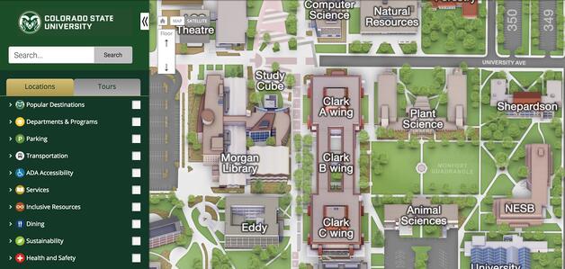
You’ve got a beautiful campus, full of history and culture. Show it off! Sure, students can follow your social channels, read brochures and talk to friends, family and advisors. But giving a student interested in environmental biology the ability to zoom in on the campus greenhouse from their laptop, aided by a detailed overview of programming and activity, is going to ‘wow’ them right away. They’ll want to learn more.
Highlighting bike racks and coffee stops on campus welcomes bike commuters hoping to fill up their mug on the way to class. On CampusBird maps, detailed 3D rendering of specific campus facilities and conveniences is an unparalleled way to answer student and visitor questions before they even have to ask them.
Take the burden off your plate.
On the note of answering questions: there is no limit as to the amount of information that can be incorporated into a an interactive campus map. 3D renderings can be accompanied by labels, photo galleries and video, and clickable structures or highlights can be hyperlinked to a specifically dedicated website.
The CampusBird platform easily integrates with ESRI/ArcGIS maps.

Wanting to make the facilities team happy in addition to the marketing team? CampusBird easily works with ESRI’s ArcGIS. You can choose what data feeds should be pulled from ArcGIS into CampusBird. This helps you provide up-to-the-minute information on traffic, parking, construction, events, or emergencies, as they happen. Your interactive campus map can become an even more useful data point for the community, giving current students and faculty a reason to bookmark the map in addition to prospective students and visitors. Read more about the complementary nature of CampusBird and ESRI.
All of this leads to a strong ROI.
Modern tech is an incredible asset for any institute of higher education – and when used to its potential, can benefit everyone involved with the school. CampusBird’s campus map technology provides valuable, actionable information for everyone from the tenured professor who is on campus every day, to the alumni attending a reunion football game, down to the first-time campus visitor checking out the school to see if it’s the right fit for them.
Convenience is everything these days. With beautiful 3D renderings and real-time campus data, your admissions department will know your digital presence is optimized. Who knows – with the map answering so many questions, the department may find some extra time to complete that project you’ve been meaning to get to.