Launching your campus map at the ideal time for your students, staff and visitors plays a large role in the success of your map. After all, the map is created primarily for those needing information about the campus. It provides the perfect opportunity to help visitors and newcomers find their way around, while also showcasing the school’s biggest selling points.
When is the best time to launch your campus map? The answer depends on who the target audience of your map is. For most schools, it is prospective students and their families who are searching and comparing schools across the country and even overseas. Current students often use interactive maps to stay up-to-date on campus events and updates concerning construction work, road closures, and live parking/transit information. Launching a map, or a layer on the map, geared towards them will draw traffic at an entirely different point in the year.
Let’s take a look at the best times to launch your campus map for different audiences, and walk through the map-building process.
When is the Best Time to Launch a Campus Map for Prospective Students?
This is often the first question that comes to mind – particularly for those in the admissions department. An interactive campus map is a great tool to help prospective students familiarize themselves with the campus, explore the surrounding area, and get a better idea if your school is the right fit for them. The busiest time of year for admissions officers begins at Thanksgiving. By this point in the fall, high school seniors are hard at work applying to college and making final decisions on where they’ll land themselves in the next year.
However, it is often during the summer that students actually visit a campus. Maybe it’s on a road trip with their family, or perhaps on a quick weekend trip. Because of this, summer is a great time to launch a campus map for prospective students. Prior to arriving, visitors often like to familiarize themselves with the campus so they know their way around, learn about new things, and figure out where they want to spend their time. If the student already has a major in mind, they may want to locate where that particular department is and get a feel for the classrooms and available resources.
When is the Best Time to Launch a Campus Map for Current Students?
When it comes to launching a campus map or a map layer dedicated specifically to current students, the best time to launch may be at any point in the year when the map/layer is relevant. Current students are already familiar with campus, thus they are more likely to use an interactive map for a specific event as opposed to obtaining general campus knowledge.
Launching a layer for homecoming week, for example, helps current students know what to expect and where to be for certain activities and events around campus. Graduation is another source of anxiety – launching a layer a few weeks prior to the big weekend helps both students and family members prepare for road closures, ceremony locations, and parking.

What Goes into Launching a Campus Map?
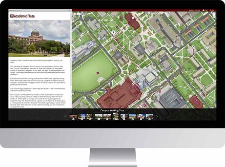
Looking at campus maps may leave you with a number of questions. After all, they are full of vivid details and loads of information. Schools are often concerned about the map development process, assuming it takes forever to put a 3D interactive map together. The truth is, the entire process can be completed in just a few months. It all comes down to planning, documenting, and getting input from departments and groups across your campus. Let’s take a look at what goes into launching your campus map.
- Speak with each department to develop a comprehensive database of information. Each department, group, and organization on campus has their own unique selling points – the concept of an interactive campus map is to highlight all of them. Gather information from across campus and develop a production timeline along with your map developer. Give each contributor a deadline to get their information submitted (including photos – 360 degree panos if that’s in your plan) and work with the developer to make sure everything is included.
- Plan the campus map to function as both a navigator and glossary of resources. Students, family members, and campus visitors reference interactive campus maps for multiple purposes. Wayfinding is important, of course, but the true value comes from using the map as an index. Don’t just show where the Engineering hall is, tell the story of the department and its personalities!
- Develop a post-launch marketing plan. Campus map developers work directly with schools to build the perfect interactive 3D map. When the map truly tells the story of a campus, it is time to push it out to the world. Here are a few points to consider after the initial development of the map:
- How will the map be marketed?
- Who will make decisions and implement map updates, as needed down the line?
- How can we help students and visitors get the most out of our campus map?
Overall, summer is generally a great time to launch your campus map to ensure everyone can get the information they need before the semester begins. Building a valuable, comprehensive map takes time and patience, thus, it should be launched on the ideal date to ensure its utmost level of success.