Over 20 million (!) students will be heading back to college this year. And from now until the end of September, students will be saying goodbye to summer vacation and hello to a new academic year in the classroom. So up until that first day of school, students will be packing and preparing for the big day.
With so many people moving on and off-campus, finding critical information, navigating the crowds, and getting to know the campus and greater areas can be difficult. Interactive campus maps and virtual tours are among the best tools to help incoming freshmen, new students, parents, and even faculty and staff.
Orientation
We are in the midst of college orientation season. Where there are thousands of excited and anxious incoming students with a host of equally anxious parents. In the midst of all this emotion, everyone is trying to get to know the area, find their way to the gym, the dining hall, and the dorms. Someone is inevitably going to get lost.
Traffic to Concept3D maps spikes in a big way during orientation and particularly move-in day. Mobile traffic spikes are HUGE as people on campus dive in to get the information they need and find their way around. Interactive maps make it easy for visitors to check out campus online before their arrival and the busy days ahead, giving them a much better sense of the campus size, building locations, parking, transportation, things to do, and where to go. It’s more than a convenience; interactive maps help people become more comfortable with your university as well as leading to a less clustered and more seamless orientation weekend.
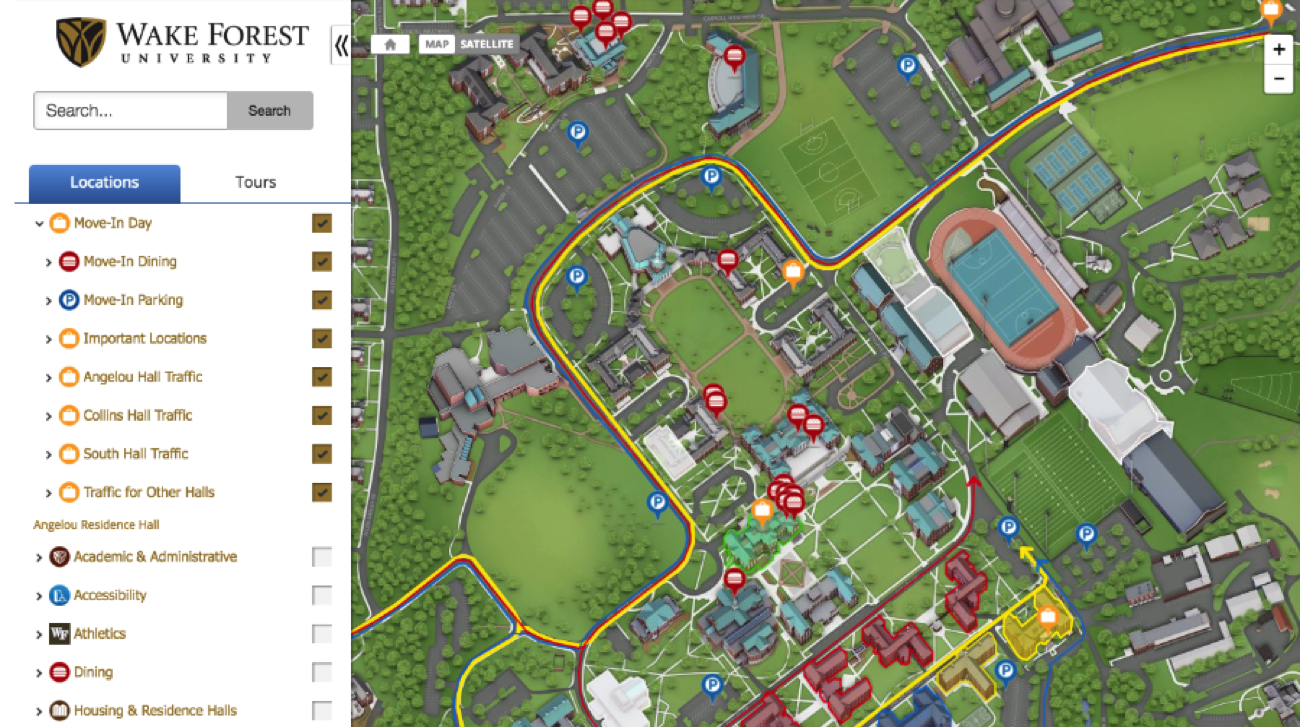
Move-in Day
Jam-packed cars, moving bins, and thousands of people trying to navigate their way into a new dorm room on a blazing hot summer day. This is the reality of move-in-day. It’s the same amount of stress as it is exciting, and for freshman students leaving home for the first time and moving in with a complete stranger, move-in-day can be overwhelming.
With a custom move-in day layer on your interactive map, students and their parents can plan accordingly. The layer – easy to build and toggle on and off – can have all sorts of features including temporary and long-term parking for specific dorms, where to recycle cardboard boxes, and even when the bookstore and cafeteria open and close (because nothing is worse than being hangry on move-in-day). Several schools also offer specific things for parents to do – campus walking tour, off-campus attractions, history, etc. Below is an example of a campus walking tour powered by the Concept3D system (and complete with the ability to dive into a location with the 360-degree pano images).
Daily Campus Navigation
While a big spike in interactive campus map traffic may happen at move-in day, we do see consistent usage throughout the course of the year. Because from freshman to senior, the beginning of every school year comes with a new class schedule and most likely classrooms and buildings that are new. Which means finding buildings you’ve never seen, with names you don’t know how to pronounce while trying to calculate how long it will take you to get there. Because on a Monday morning, every minute of sleep counts.

Interactive maps are the ideal tool to help students plan out and navigate campus that first week of school, and a resource they can count on thereafter. And, interactive maps are also a great way to help people get around – sharing a direct link to a building or just how to find the map itself.