From CampusBird Blog
Online campus maps haven’t always been as dynamic as they are today. With today’s technology, we are able to create beautiful maps with 3D building renderings and interactive capabilities. Users can click on an icon to make a pop-up appear, complete with high-resolution images, videos, slideshows, and more.
One particularly exciting and helpful tool now available for interactive campus maps is data integration, incorporating live data feeds to provide pertinent information and bring the school to life for both online and on-site visitors. Below are some creative ways you can use data integration to make your map an important resource for all users, whether prospective or current students, faculty, or other visitors.
Why Data Integration is Key to Marketing Your Campus Map
We live in a world where people want and expect information instantly. The need to find information quickly, especially from a mobile device, runs the world. Data integration into your campus map provides site visitors an incredibly helpful tool, whether it’s knowing how many parking spaces are left in a certain lot or when the next bus is coming, having real-time information at your fingertips makes life easier. In addition, ensuring your map is mobile-responsive is important to ensure users can benefit from live feeds. This resource is not only a valuable marketing tool, but is another reason why an interactive map is so important for your campus.
Creative Ways to Use Data Integration with Your Map
Live Parking Feeds
Providing your school’s visitors with live parking feeds is an incredibly helpful tool. No one likes driving around trying to find parking when they’re trying to get to class, an event or a meeting. It’s not only a frustration for the driver, but it also causes congestion and unnecessary pollution on campus. With live parking feeds, as visitors approach campus they can see which lots are already full, which ones are filling up, and which ones are wide open. Color coding
Live parking feeds are also incredibly helpful for event-day and construction staff directing traffic and parking. We worked with Arizona State University to integrate and display real-time parking lot occupancy data. By looking at the parking occupancy feed in the interactive map, visitors can determine whether a parking lot is full or not within seconds, as lots are color coded: green for low occupancy, yellow for filling up and red for full.
Real-Time Transit Data
Students, faculty, and other visitors to campuses that rely on public transportation are sure to appreciate live transit feeds. We partnered with Ride Systems LLC to integrate their Live Bus Tracker technology into campus maps for real-time transit data integration. The system uses GPS tracking to provide users with the ability to view bus routes, see real-time bus locations, and estimated times of arrival.
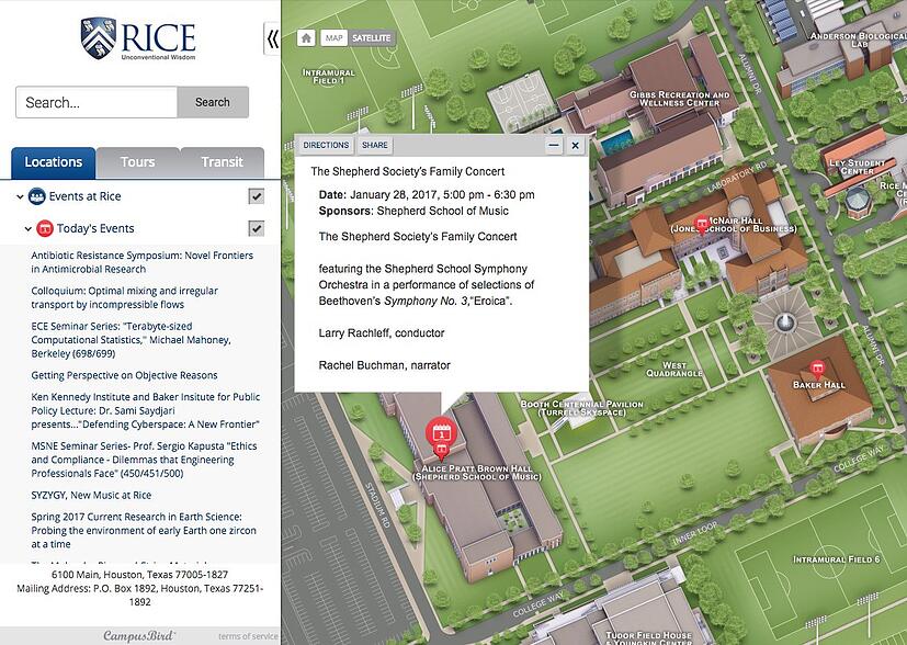
Rice University in Texas was one of the first to use the new live transit feature on their interactive map. Riders love the utility of having real-time bus information and routes embedded right into their interactive campus map, especially since it can be accessed via mobile.

Weather Updates

Weather updates are a great tool to offer anyone planning to be on campus, and having weather data integrated into the map makes for easy access. You can also alert students about inclement weather, and any closures they can expect.
Social Media Feed
Social media plays an ever more important role in disseminating information and keeping people connected. Universities can incorporate live feeds of their Twitter and other social outlets to keep students informed about what’s happening on campus, as well as encouraging them to share their own content.
Campus Events Feed
Getting the word out about events on campus is key to a successful turnout. Integrating a live event feed into your map allows users to see what events are happening where and when. Whether it’s commencement, a guest lecturer, sporting events, or a musical, students can join in on more campus activities if they have them at the touch of their fingers. Rice University provides a campus events feed that updates nightly.
Video Streaming
Expanding upon the live events feed, you could take your map a step further and add a live video streaming. Students and alumni who can’t make a football game or a family member that is missing a graduation could tune into a live video feed accessible via the interactive campus map. Perhaps someday students will be able to access live feeds of their classes!
Ole Miss got creative with video streaming, and has a live feed outside of an on-campus Starbucks to show if there is a line; very helpful for a student in need of a coffee for that early morning class, and one of the most popular map uses!
No matter how you choose to use data integration, your users will appreciate this key resource. Encourage students, faculty, and visitors to use the map regularly for real-time information. Promote the map through your various marketing outlets. The opportunities of data integration are endless, and the benefits are sure to pay off.