Let’s Talk
Create location-driven virtual experiences that immerse your viewers.

When prospective students explore their options, a college’s website is usually their first stop — and the campus map is a prime opportunity to explore university life for themselves.
A well-designed map helps students visualize a campus’ layout, plan their visit, and navigate more confidently — especially for those with accessibility needs. At this point, an interactive map isn’t just a bonus. It’s something students expect.
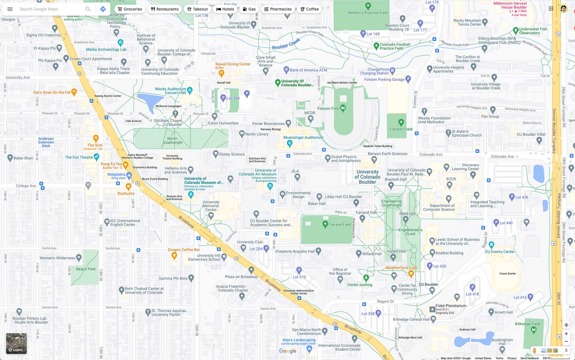
Google Maps is a popular resource for embedded campus maps, and for good reason. It’s easy to use, widely known, and generally reliable. However, it wasn’t built with the complexities of higher education in mind.
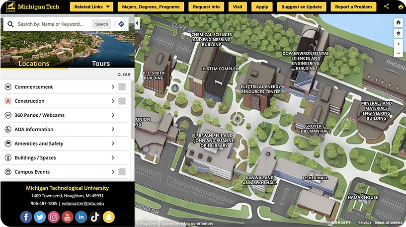
To turn your campus map from a basic utility into a tool for engagement, recruitment, and inclusion, you may need something more. Concept3D offers a customizable, higher-ed-focused solution designed to bring your campus to life online.
Google offers top-of-the-line navigation, but a custom map built with a tool like Concept3D gives your institution the opportunity to tell its campus story. Maps are more than directional tools — they’re a key part of your website content, which plays a critical role in student recruitment. The right platform for you depends on how you want to leverage your campus map.

Concept3D is built specifically for colleges and universities, offering features tailored to the higher ed experience.
Schools can spotlight what matters most to them — whether that’s emergency blue light stations, bicycle repair stands, or campus landmarks tied to school history and traditions. Interactive tours are built directly into the map, offering prospective students an immersive look at campus, complete with embedded video and audio.
Accessibility is another major strength. For example, a student who uses a wheelchair can map out barrier-free routes between classes, eliminating confusion and frustration before they even arrive on campus.
Google Maps is highly reliable for broad navigation needs, and its wide popularity means most people already know how to use it. It’s simple to embed, and basic maps are free, which is a nice perk.
While Google Maps meets general navigation needs, it’s built for the general public — not the unique demands of a college or university. Its features are broad by design and may not support the depth of storytelling or customization many institutions require.
Like Concept3D, it can highlight points of interest, but it doesn’t offer virtual tours, making it harder for schools to share the full experience with prospective students. Google Maps includes user-uploaded photos and videos, but schools have little say in what appears or how it represents the campus.
Another limitation is control. Because Google prioritizes its own business interests and advertising partners, schools may find it difficult to feature their own recommended stops, like partner hotels or dining options, without competition from paid placements.
Ultimately, colleges have limited control over the look and feel of their map on Google. That can lead to a disjointed brand experience, especially when maps are embedded in a carefully designed website.
The look and feel of a campus map can make a strong first impression, especially for prospective students exploring your site for the first time. Branded digital mapping ensures a consistent user experience that reflects your institution’s identity and reinforces your online presence.
Features
Concept3D
Google Maps
Custom 3D renderings of your campus
Your logo and favicon
Custom fonts and colors
Custom colors
Embeddable onto your website
Concept3D gives colleges and universities full control over their campus map’s branding and design. You can incorporate school colors, a logo, and custom icons to align with your visual identity.
One standout feature is the ability to use custom illustrations or photography of campus buildings and grounds, including optional 3D renderings. This allows institutions to showcase their campus in the best possible light.
You can also offer multiple map views — such as traditional street view, 3D models, or illustrated layouts — depending on what best supports your goals.
Customization is more than visualization. If a building name changes or a new parking lot opens, updates can be made immediately without waiting on a third party. Concept3D also allows schools to set preferred routes for special occasions, such as move-in day, commencement, or big games, giving them full control over how visitors navigate campus.
Google Maps offers some customization options. Like Concept3D, it allows users to highlight points of interest and customize icons. There are also some options to adjust map colors using a feature called “map style.”
Still, Google Maps will always feel like Google. The company’s logo and branding are required, and users are not permitted to remove or alter attribution. Institutions can’t add their own logo or fully tailor the map to match their brand identity.
Schools are also subject to Google’s choices when it comes to imagery and updates. For instance, if Street View captured your campus on a gloomy winter day, that’s what prospective students will see, regardless of your preference to highlight a vibrant fall scene. In some cases, user-uploaded photos may appear that don’t reflect the campus in the best light.
Google’s massive scale is part of what makes its mapping tools so powerful, but it also means their attention is spread across countless organizations. Changes to building names, streets, or routes can take months or years to be reflected, depending on Google’s update schedule and priorities.
Ultimately, you’re working within a framework you don’t fully control. And without the ability to white-label the experience, it’s difficult to create a fully branded, consistent look across your website.
Colleges can add a deeper layer of engagement to their digital presence by building interactivity into their campus map. This user-friendly, dynamic way of exploring campus serves as a powerful digital introduction for prospective students.
Features
Concept3D
Google Maps
Campus storytelling
Point-to-point Wayfinding
Accessible software
Interiors (and interior wayfinding)
Categorized locations (parking, elevators, etc)
Timely edits and personalized support
Concept3D’s interactive maps bring campus life to the screen in a way that’s both intuitive and meaningful. Students can explore on their own devices, browse locations visually, or follow custom routes tailored to different needs and interests.
Built-in virtual tours with video, sound, and storytelling help schools communicate their legacy, traditions, and personality through place. For example, a map could highlight the statue students rub for good luck, the building that once served as a wartime hospital, or cutting-edge research facilities that show how the college has evolved over time. Some institutions even use interactive walking tours within the map, allowing prospective students to explore specific majors, programs, or parts of campus on their own time.
Universities can also create custom tours specific to your majors! Show future students what a walk on campus will be like for business students, or a dining tour of favorite restaurants on campus.
Location-based content adds even more value. Institutions can offer tips on where to park, grab a coffee, or find a nearby restroom, all within the map interface.
Accessibility is also a core focus. Concept3D maps can be navigated using a keyboard and include features like defined wheelchair-accessible routes, ensuring that all students feel welcomed from the start.
Over the years, Google Maps has introduced a variety of interactive features. Most notably, users can get turn-by-turn directions for driving, biking, or walking. They can also drop pins, explore areas through Street View, and interact with map layers for real-time traffic and transit information.
Maps also performs well in terms of accessibility. The interface is keyboard-navigable, and it includes directions for wheelchair users. However, because indoor mapping isn’t available for higher educational institutions, accessibility features are typically limited to outdoor pathways and entrances.
While Google’s interactive features are powerful and widely loved, they’re built for the general public. They lack the education-specific features — like virtual campus tours and custom interactive layers — that help colleges connect with prospective students on a deeper level.
Your campus map can do more than guide visitors — it can become a real-time tool for sharing important campus conditions. With the right API integrations, all navigational information lives in one user-friendly place, combining ease of use with real-time updates to enhance the student experience from day one.
Features
Concept3D
Google Maps
Embed custom maps on your website
Interior wayfinding
Guest, student, and faculty specified parking
Real-time parking availability
Real-time updates on campus transit (busses and shuttles)
Parking is a challenge at nearly every university. But what if students could see available spots in real time? With Concept3D, this use case is a reality. The platform supports live data integrations from campus systems, making it easy to share up-to-date information about parking, transit, campus events, and more.
Concept3D is also built to support indoor navigation. With detailed renderings of building interiors, schools can offer wayfinding from classroom to classroom, seamlessly guiding students through both indoor and outdoor spaces.

Google Maps offers simple API functionality, including custom routes and limited indoor navigation. Indoor mapping is generally reserved for select location partners like stadiums, airports, and malls. At this time, Google doesn’t map the interiors of university buildings.
Maps also doesn’t integrate with campus systems to display real-time information like parking availability, weather updates, or event details.
Some university teams prefer hands-on vendor support, while others are comfortable managing tools independently. Concept3D and Google Maps offer very different support experiences, which is an important factor to consider when choosing a campus map solution.
Features
Concept3D
Google Maps
Community support
Help site
Email support
Quarterly check-ins
Dedicated US-based client support
Concept3D provides dedicated, personalized support from day one. Every client begins with guided onboarding, where the Concept3D team helps configure every detail of the new campus map and trains staff on how to maintain and update it over time.
Support doesn’t end after launch. Clients have ongoing access to specialists for troubleshooting, questions, or strategic guidance as their map evolves.
Embedding a Google Map on your site is largely a self-serve process. Google often relies on its user community to contribute updates and maintain accuracy.
For colleges using Google Maps, this often means handling customizations like styling, imagery, and routing on their own, with little direct support from Google.
When organizations do need assistance, response times can be slow. Any requests for changes or personalized service compete with a global queue of users across countless industries.
Google Maps is a great option for basic navigation — it’s familiar, affordable, and gets people from point A to point B. But when it comes to showcasing your campus, telling your story, and supporting students every step of the way, Concept3D offers so much more.
Built specifically for higher education, Concept3D helps colleges and universities create interactive maps that go beyond wayfinding. From accessibility features and real-time data integrations to virtual tours and fully branded experiences, it’s not just a tool for prospective students — it’s a daily point of reference for your entire campus community.
Concept3D partners with higher ed admissions teams to create engaging digital experiences that connect campuses with prospective students, parents, and alumni. Our award-winning Interactive Maps, 360° Tours, and Events Calendars are designed to support your campus.


Bring your world to life virtually, showcase your location, and effectively tell your story.
See our technology come together in one seamless experience.