
A welcoming, accessible environment is an essential part of a healthy campus culture for students and their guests. But communicating all your campus’s available resources can be a challenge. A digital campus map is a comprehensive tool that can be used to highlight resources, improve accessibility, and streamline events. By building a campus map around the elements people need most, you create an enjoyable experience for everyone who uses your campus. Determining how college students use maps is the first step in creating a map that effectively meets their needs. This post highlights the most engaging interactive campus map categories to help higher education facilities design a map that attracts users and reflects your campus story.
How We Collected Our Data
We strive to support our customers with services that help them use our software effectively. One way we do this is by collecting anonymized GA4 analytics of how our maps are used, helping us better understand what prospective students, families, and campus visitors prioritize when exploring a college or university online.
Data privacy and security are top priorities that we take very seriously to protect all users who enjoy our digital products. At the beginning of a session, users can choose to share anonymous data that allows us to track and improve app performance. With data shared by over seven million users across 675 college campuses, the following interactive campus map categories were the most explored among students and visitors over the last 12 months.
The 13 Most Engaging Interactive Campus Map Categories
The most engaging interactive campus map categories include necessary resources, visually appealing elements, and entertainment opportunities. Many are easy to overlook, and some are ideal for increasing time spent on your site.
1. Parking
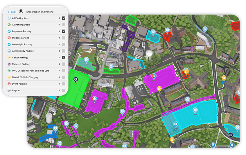
Not surprisingly, parking tops the list of interactive campus map categories for practically every location. This is the element that visitors, faculty, prospective students, and event-goers will seek out before arrival and use before taking their first step on campus grounds.
For nearly half of the students who bring their cars to campus and faculty members, accessible parking is a daily need. During events and special occasions (like move-in day), campus lots quickly reach maximum capacity. With the right interactive campus map platform, schools can list the locations of parking lots around campus, provide cost information, and share occupancy levels.
2. Dining
Meals are a part of students’ daily routines and an element of any visit, so it’s one of the most important interactive campus map categories. Adding dining locations to your interactive campus map will allow students, faculty, and visitors to easily locate all dining options on campus. You can also include details about what each location has to offer and service hours to enhance convenience.
3. Academic and Administrative Buildings
At the core of any college experience, academic and administrative buildings are the locations where students will spend most of their time. Highlighting lecture halls, classrooms, and faculty offices can help prospective students learn more about the environment they’ll be studying in and help new students plan ahead for where their classes will be.
4. Residence Halls
Housing is a vital part of the student experience. When paired with 360º visuals and housing info, this highlight on your campus map can give parents and students the information they need to make an informed choice when choosing a school. These elements are also highly trafficked on move-in days to improve wayfinding and access to necessary resources. When you use Concept 3D interactive map software, you can create a move-in day category that allows you to highlight residence halls, pick-up and drop-off areas, administrative offices, dining spots, traffic patterns, and more.
5. Athletics
Athletics play a role in the college decision-making process, student engagement, and community involvement. As a point of interest on digital maps, this category is heavily used for recruiting and on game days, to increase engagement and convenience for students and guests.
You can use athletic highlights to increase engagement during admissions by linking highlight reels and creating a tour of athletic and extracurricular facilities. On game days, your map will be a hot spot for wayfinding that can be enhanced by highlighting special routes for visitors and adding real-time updates and notifications about unexpected changes.
6. Student Services
Sixty percent of students are unaware of the full scope of services offered by their college or university. From counseling to academic support and financial aid, all the services students need should be highlighted to improve accessibility. Students and parents seek out student services during college selection, enrollment, and orientation, making these resources a vital part of the admissions process. So, highlight relevant locations (with information about office hours and parking). Also, consider linking important forms that will allow users to access the information they need quickly.
7. 360º Panoramas
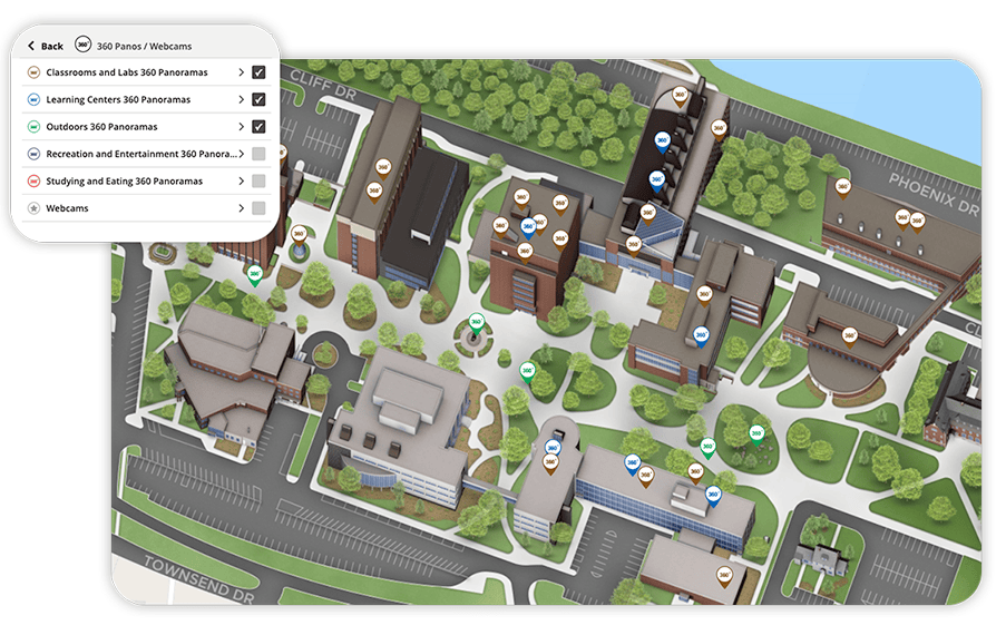
When engaging extras can be added to your interactive maps, you can give students a realistic view of life on campus. Help them imagine themselves in specific places, like classrooms, cafeterias, and residence halls. 360-degree panoramas can be used to tour specific locations and enhance the interactive experience, whether students are on campus or hundreds of miles away. These features keep users exploring longer and help prospective students make informed decisions about your school.
8. Things to Do/Entertainment
Entertainment is a vital part of campus life. Your campus map should highlight theaters, galleries, and gathering spots to communicate campus personality and help students find their perfect fit. These elements will be of vital interest to prospective students choosing schools. Current students also use them to find the hidden gem amenities that only the older students know about.
9. Transportation
Navigating sprawling college campuses isn’t always easy. When more than half of students don’t have cars, highlighting shuttles, bike racks, EV stations, and any other transport options is essential for accessibility and convenience. Transportation and transit are elements of your digital map that are likely to be used daily. When you use customizable interactive map software, you can easily integrate live transit feeds, public transportation information, bike routes, paths, and parking information into your digital map.
10. Restrooms
This small detail is one of those easily overlooked features on your campus that has a big impact. Students need to get across campus in minutes to make the next class. Visitors may be navigating an unfamiliar campus during a special event. In either scenario, easy access to the nearest restroom is always an essential part of navigation. People will use these elements of your map every day. But you’ll also get a big traffic boost from mobile devices during events and tours.
11. Construction
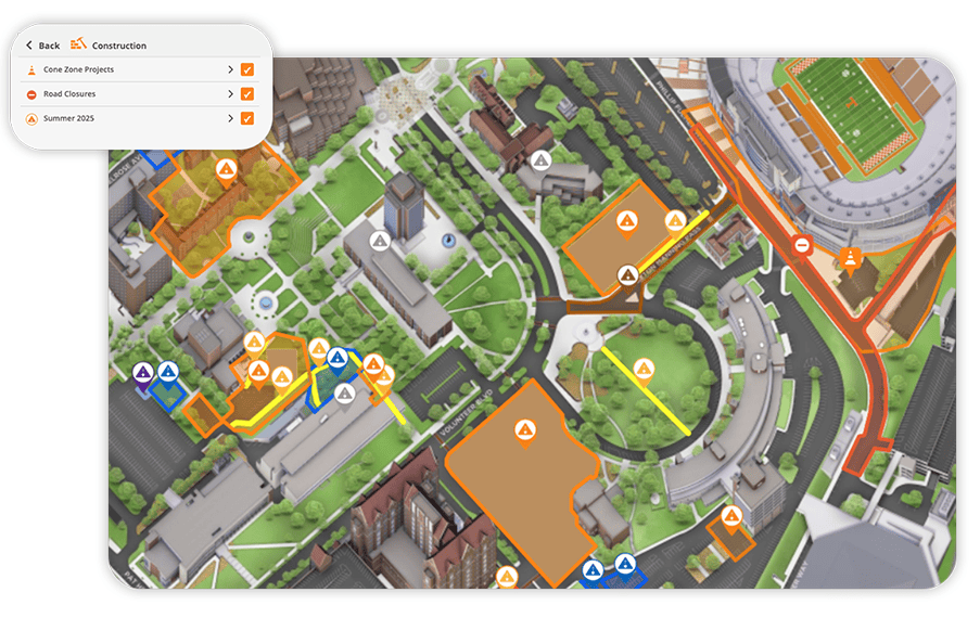
Safety is paramount on any campus. Highlighting construction helps users navigate around disruptions to avoid tardiness and potential dangers. Digital maps with real-time data will allow you to highlight closed campus areas and the best navigational paths around those areas.
12. ADA Accessibility
An estimated 3.5 million students with disabilities attend college. Wayfinding and adjusting to college life are challenging for all students. But they are especially difficult for students with disabilities who don’t have access to the resources they need. Interactive campus maps can improve the experience for all students and staff by highlighting campus accessibility resources. These include wheelchair-accessible entrances and bathrooms, elevators, and ramps.
13. Sustainability
Eighty-five percent of students say sustainability is at least somewhat important. Also, 45% consider a campus’s environmental sustainability in their college enrollment decision. Your interactive campus map allows you to tell a deeper story about campus values by showing where solar panels, green buildings, and compost stations promote a sustainable campus.
Why “Directions” Isn’t Listed
You may be surprised to see that “directions” isn’t listed as a top category on digital maps. “Directions” or “wayfinding” would undoubtedly be the most engaged-with category on campus maps by the numbers, but it’s not technically a category. Categories are similar to folders and subfolders with locations within them.
Interactive campus maps from Concept3D offer turn-by-turn wayfinding indoors and out. This allows users to access real-time directions to any location on campus. With 3D renderings and live data feeds, navigating campus has never been easier. Users can immediately gain access to the fastest route between two points. They can also specify wheelchair accessible pathways to safely and comfortably reach their destination.
How to Use This List to Improve Your Map
This list comprises the interactive campus map categories that receive the highest volume of engagement across our maps. It’s a great starting point to select categories that will enhance the user experience and highlight your school’s offerings. However, the list isn’t set in stone. You’ll probably want to include additional features and maybe omit a few you could do without.
These tips can help you utilize all the information in our list while making your campus map your own.
- Start with the categories your visitors are already looking for.
- Think beyond logistics to make your campus map a complete brand experience with interactive 360-degree panoramas, videos, and links with added information.
- Take advantage of digital connectivity to link to relevant resources, including campus visit info, tour registration, housing pages, and more.
Engage Students and Guests With Interactive Map Software From Concept3D
Learning about how college students use maps and the most interactive campus map categories across college campuses can help you develop an engaging digital map. You can better ensure students and guests can efficiently navigate everything from daily schedules to large events. At Concept3D, we help colleges:
- Reduce common wayfinding challenges.
- Build a sense of community with interactive maps.
- Showcase what is unique at each location.
Want to learn more about how Concept 3D’s industry-leading interactive maps can transform your campus? Contact us today to talk to one of our experts or schedule a demo to see our software in action.