The Leading Interactive Campus Map Software in Higher Education
Highlight what makes your campus unique, Improve interior and exterior campus navigation, and engage your students.
Most Universities Already Rave About Concept3D


Request a Demo


We Make it Amazing
8.5 Min
Avg. Time on Page
Results made possible by Concept3D
Student Leads
88% of students use campus maps during their admissions process. Leading marketers use our maps to share their campus story while acquiring and engaging leads.
Current Students
54% of the student population uses our interactive campus maps on the first week of school, internal reporting found. From move-in day to commencement, our interactive maps help students feel more connected to campus.
Interactive Map Features
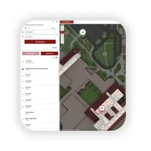
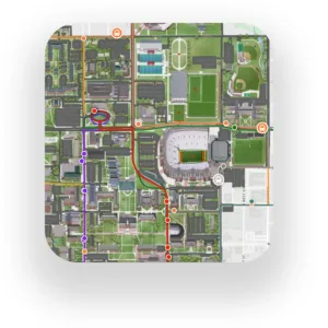
Wayfinding
Users can easily generate the best route with turn-by-turn directions from anywhere on campus, even indoors.
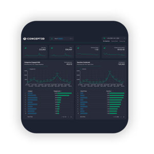
Analytics
Event Overlays

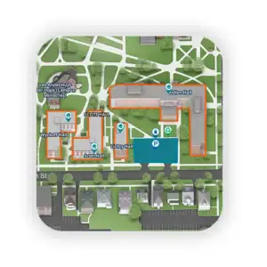
3D Renderings
Your buildings and environment are brought to life by a design team that obsesses about the aesthetic of your interactive map.
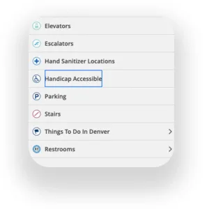
WCAG 2.1 AA Compliant
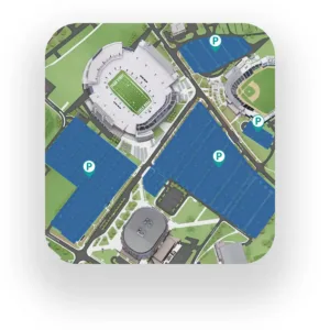
Parking
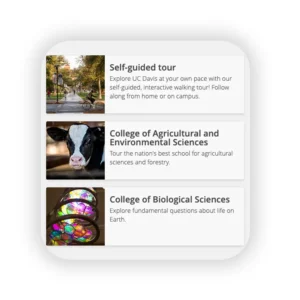
Unlimited tours
Live data feeds
Branding
Frequently Asked Questions
Why does digital accessibility matter? And are your maps accessible?
Digital accessibility ensures that everyone—including users with disabilities—can interact with your campus map. It’s essential for compliance, inclusivity, and a better user experience. Yes, Concept3D’s Interactive Map is designed to meet WCAG 2.1 AA accessibility standards.
Can your Interactive Map generate indoor and outdoor directions?
Yes. The Interactive Map supports both indoor and outdoor wayfinding. Visitors can get step-by-step directions between buildings or even within complex facilities like residence halls or student unions.
What happens if a building or street name changes?
No problem. You can update labels, descriptions, and map layers at any time using the intuitive CMS. Name changes, renovations, or re-routing are easy to reflect on the map without starting from scratch.
What if we have an ArcGIS map?
Our platform supports integration with ArcGIS feeds. That means you can overlay GIS data or maintain your existing workflows while delivering a far more engaging, branded experience for users.
How long does it take to set up an interactive campus map?
Typical implementation takes 6–10 weeks depending on how much information you want on your map,. Our team handles onboarding, design, and training to ensure a smooth and successful launch.
What is your interactive campus map used for?
Our maps are primarily used to increase admissions by telling your campus story in a way that converts to application inquiries and on-campus visits. Marketers also use it to showcase key events and facilities on campus.
Can the Interactive Map be embedded on our website?
Yes. We have many different embedding options, but we do recommend embedding the full map on a dedicated page for a better mobile experience. We also offer CNAMES for your map and extensive branding to ensure a seamless experience.
How do I make updates?
You’ll have access to a powerful Content Management System (CMS) that allows your team to add, remove, or edit map elements in real time. No design skills or coding needed—just point, click, and publish. If you have managed updates, you’d just email our team what you wanted updated.
What happens if a building or street name changes?
No problem. You can update labels, descriptions, and map layers at any time using the intuitive CMS. Name changes, renovations, or re-routing are easy to reflect on the map without starting from scratch.
How often can we update the map?
You can update your Interactive Map anytime using the CMS dashboard. Whether you’re adding new buildings, updating points of interest, or adjusting wayfinding routes, the system is built for fast, flexible updates—no coding required.
Join the Marketing Trailblazers Leading Higher Education
8,000,000+
Yearly Users
4.5 Star
Rating on G2
675+
Campuses Served